
EcoCAT uses geospatial analysis in order to streamline the review process. In some cases, a review can be automatically completed (“terminated”) by EcoCAT if no resources are found in the area under consideration.
The project’s county, section, township, and range are entered on the Location Information page. When the Go To Map button is clicked, control is transferred to the Map Tool page.

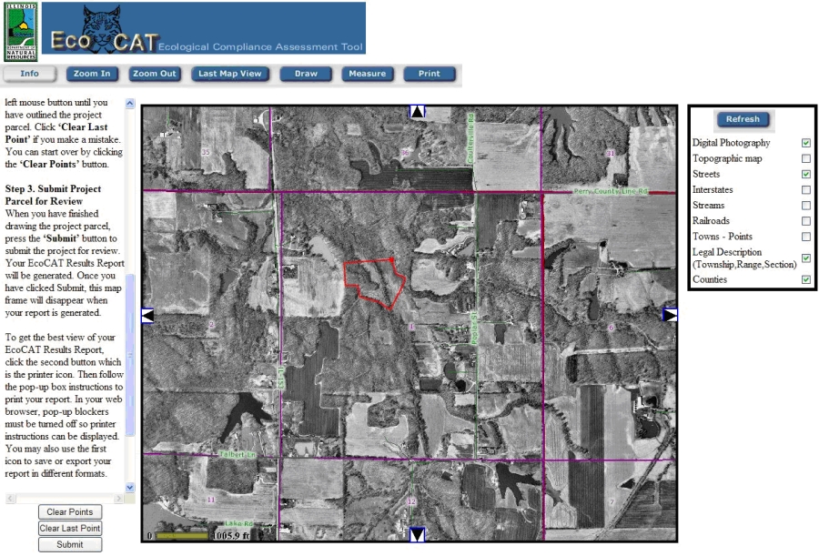
The Map Tool page displays a map of the chosen county, section, township, and range. On this page, the site boundaries need to be drawn, and the Submit button pressed. The process is as follows:

You should see the county, section, township, and range you entered. In the center of the map should be the section you entered. To get more detail or to move around the map, use the Zoom buttons to zoom in or out and the arrows on the map to pan north-south or east-west. Clicking the Zoom In or Zoom Out buttons will change the function of the mouse pointer to a zoom in or zoom out tool. You will need to click the Draw button to turn the mouse pointer back into a drawing tool.
To the right of the map is a list of map features that can be turned on or off by clicking in the check box. Click in the check box and then click the Refresh button to turn the map features on or off. Turning on the Topographic map will display a transparent topographic map over the digital photograph of the area.
Step 2. Draw the Project Parcel
Pick a corner of the parcel and click the mouse to create a starting point. Continue clicking the mouse until you have outlined the entire project location. Click 'Clear Last Point' if you make a mistake. You can start over by clicking the 'Clear Points' button.
Step 3. Submit Project Parcel for Review
When you have finished outlining the project location, press the 'Submit' button to submit the project for review. Your EcoCAT Results Report will be generated. Once you have clicked Submit, the map frame will disappear when your report is generated.
You may only submit one project parcel at a time. To enter another parcel you must go back to the EcoCAT website to complete the project entry process again.
A resource inquiry is then performed, and the site location and resources are associated with the project. The status of E&T, Wetlands, and information reviews associated with the project are set by EcoCAT, depending on the results returned.
Finally, a Results report is generated by EcoCAT.